


防災セーフティマップ app for iPhone and iPad
Developer: Takashi Tokuda
First release : 12 Jul 2014
App size: 23.05 Mb
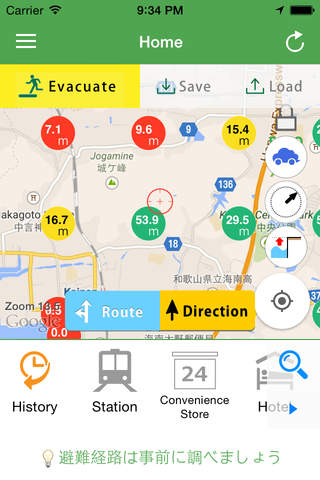
DPMaps is an useful app in both daily life and emergency. Find more than 126,000 Evacuation Facilities in all over Japan and can help you get there faster by direction and route navigation. Easy search for convenience store, popular restaurant or various useful places just by tapping the big icons.
- Find more than 126,000 Evacuation Facilities in Japan and navigate by route and direction
- Easy tap action to search for station, convenience store, popular Ramen shop and so on
- Save and load maps and Evacuation Facilities for when cannot connect to the internet
- Display altitudes (height from sea level) around you
- Display various types of maps such as past disaster maps in Japan (The East Japan Great Quake, Mt. Ontake Volcanic Activity and so on)
- Display Evacuation Distance
- Send the destination to car navigation systems via NaviCon app released by Denso
(The detail of NaviCon app ; http://navicon.denso.co.jp/user/)
- Search the place title and address on the internet easily
- Award
The Geospatial Information Authority of Japan (GSI) Disaster Prevention Apps Award (2014)
GSI Disaster Prevention Information Design Award (2014)
- Source
The Geospatial Information Authority of Japan (GSI) Database and the National Land Numerical Information